“The Internet is rapidly becoming a resource people turn to for a number of services. In particular, a number of business directory services have been established on the Internet, replacing the traditional business directories distributed by telephone companies. Such business directories allow the user to search for a specific company using the Internet. In addition, other sites on the Internet provide map services for a variety of purposes. Some sites can simply store a large number of maps which the user can view. Other sites for a particular business or operation will often include a map showing their location. Some of these may provide directions to the location of the business in response to a user input. In addition to the Internet, some cars are now provided with maps, using, for example, satellites for global positioning to determine the location of the car. A user can input a query and receive directions from the user’s location to a particular location to which the user wants to drive”.
The above passage, which sounds like a small journey into the past, comes from the patent application of one of the greatest modern innovators. The patent entitled “Interactive network directory service with integrated maps and directions” no. US5944769A (filed in 1996) is the most popular one in Elon Musk’s portfolio. So far, it has been cited in 220 patent applications from companies such as Google, Intel Corporation and Sony Corporation, which proves the great value of this solution.
This invention relates to a network service that integrates business data and maps. At present, we cannot imagine life without maps on which we can quickly locate the data we need concerning various services, but back in 1996, such a solution was very innovative.
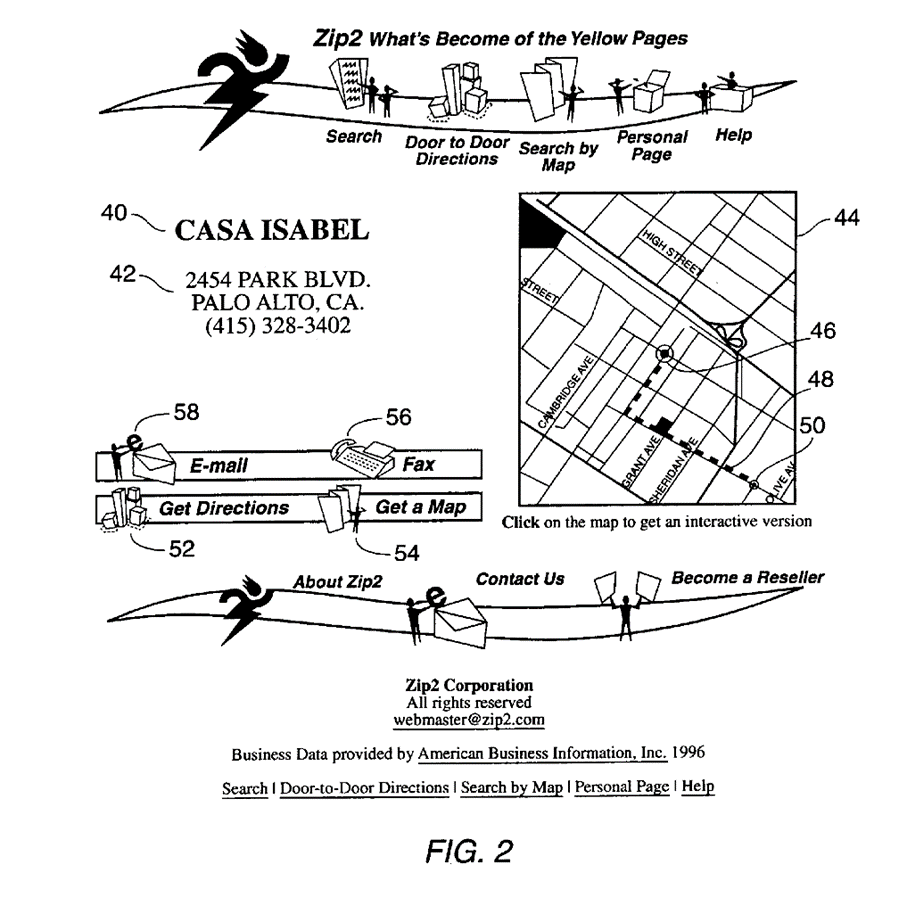
The solution describes a procedure in which the user first contacts the server website and searches for the necessary data, and then a map is generated which is subsequently sent to the user device. The map can usually be centred around the location indicated in the search. When users receive the map, they can request directions. This request is then sent back to the server. Next, the server creates a route and overlays it on the map. Finally, the map with the route is uploaded and displayed on the user device.
One of the archive figures from this application showing a diagram of a typical user display is provided below. It shows the search result and the accompanying map with overlaid route information.

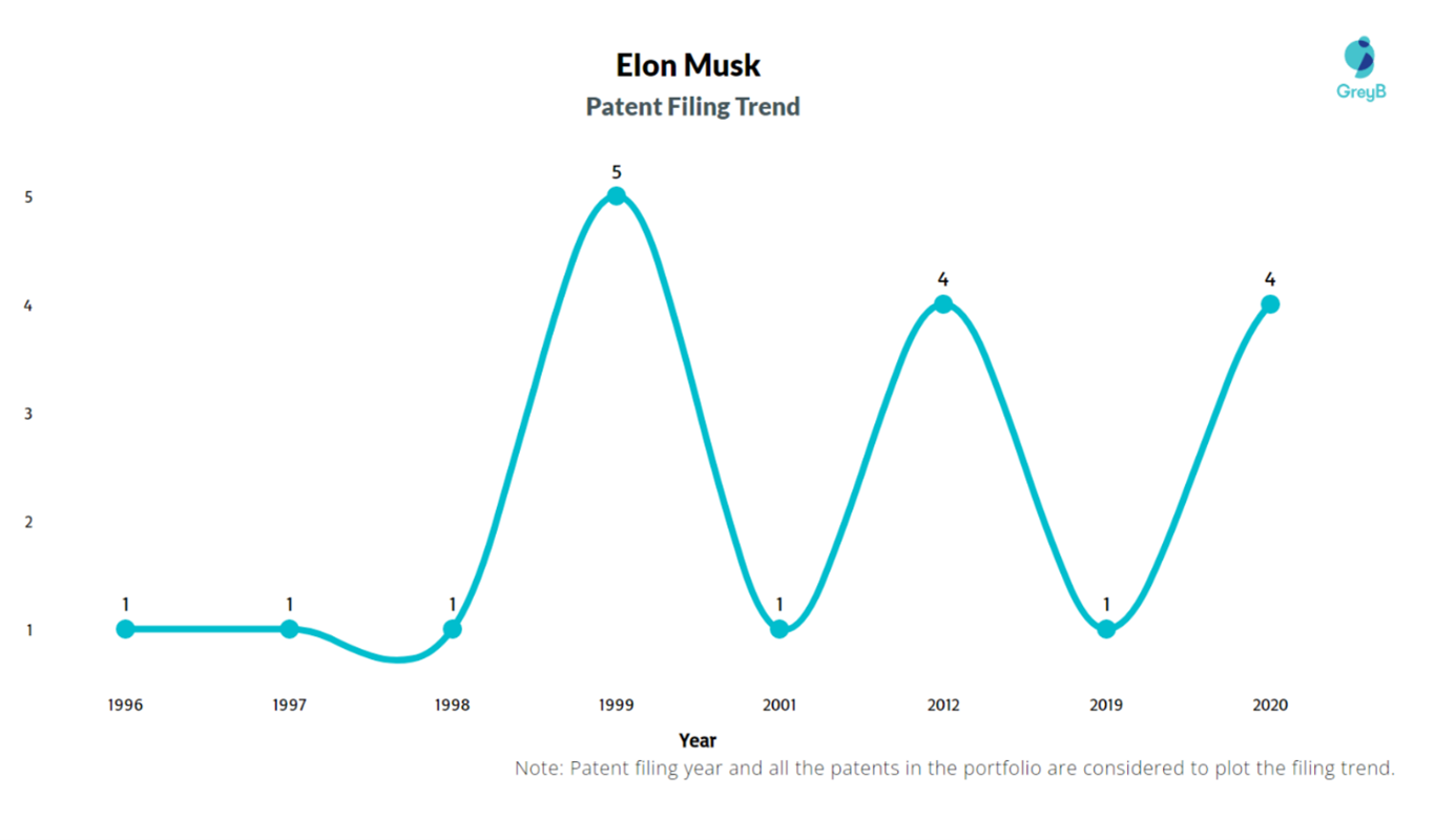
Despite being recognised as a visionary, Elon Musk himself does not have many patent applications to his credit (as a creator). The following chart shows the number of applications from Elon Musk.

The following are among the most frequently cited innovative applications for solutions invented by Musk:

The number of citations of patent applications (patents) is the same indicator as the number of citations for scientific works. Such citations are often used by competitors or people from related industries. They can provide data on the current state of technology in a given industry. Using this indicator, you can follow current trends and the development of a given market and understand what the competition is focusing on. Accordingly, such citations are particularly useful for business analysis purposes. They can help to identify licensing opportunities (as part of a market demand analysis for a given invention). It is worth mentioning that older patent applications and patents will have many more patent citations than new patents and patent applications.
In turn, Elon Musk’s latest application (developed in cooperation with other designers) made on behalf of Tesla INC, “Autonomous and user-controlled vehicle summon to a target”, bears the international application number PCT/US2020/017316 and was filed in 2020. This solution relates to a system that receives the geographic location data of a user away from the vehicle and uses a machine learning model to generate the vehicle’s environment using sensor data. In the next step, it calculates the route to the user’s location and generates a command to automatically navigate the vehicle based on the mapped route and updated video data captured by the cameras. The user’s location can be updated (if the user moves), the car also updates its path to the target location. The vehicle route is generated on the basis of vehicle operating parameters, such as the turning radius of the model, vehicle width, vehicle length, etc. The optimal path is selected based on selection parameters, such as distance or speed, etc. Since the vehicle moves along the selected route automatically, it constantly updates its surroundings and does safety checks on the basis of which it can replace or modify the automatic navigation. The vehicle can be stopped if an object is detected, for example, by ultrasonic sensors that can be used to detect potential collisions. The user can also monitor the navigation at any time and cancel the vehicle summon.
Figure 8 is a diagram illustrating the embodiment of a user interface for automatically navigating a vehicle.

This application is currently pending at the Patent Offices of Japan, Israel, Canada, Australia, China, South Korea and the European Patent Office.
Today, autonomous vehicles are considered one of the greatest achievements in the field of transport, they have the potential to reduce the number of road accidents and improve transport efficiency. Vehicles are being tested all over the world, however, safety issues still remain in question. But should we really be afraid? Maybe, paradoxically, it is the robots, properly programmed, that will cause fewer traffic hazards?


